Pulju Wilderness Area Directions and Maps

Directions
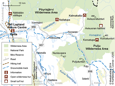
Pulju Wilderness Area is located in the municipalities of Enontekiö and Kittilä. Road 956, from Nunnanen to Pulju, runs through the wilderness area.
By Car
- Road 956 cuts through the centre of the wilderness area. It runs through the village of Nunnanen in Enontekiö and leads to the village of Pulju in Kittilä. Nunnanen is about 44 km from the village of Hetta; the municipal centre of Enontekiö. To get from the village of Kittilä to the village of Pulju take road 79 north and turn onto road 956 at Sirkka.
A snowmobile track runs by the road from Pulju to Nunnanen and on from there to Hetta. - To the west of Pulju Wilderness Area there is a road, which runs from Nunnanen to to Kalmakaltio Spring. To the south road 957 runs from Peltovuoma to Raattama.
To get to Kalmakaltio from Hetta take road 956 for about 44 km to the village of Nunnanen and turn onto the road to Kalmakaltio. - To get from Hetta to Peltovuoma drive 30 km east along road 956.
- When going to Raattama from Kittilä one possible route is to take road 79 to the village of Rauhala and turn onto road 957 which follows the northern shore of Lake Jerisjärvi.
- Driving directions to Fell Lapland Visitor Centre.
- Driving directions to Pallastunturi Visitor Centre.
- Driving directions to Yllästunturi Visitor Centre Kellokas.
By Public Transportation
- Coaches (matkahuolto.fi) travel from Rovaniemi to Enontekiö.
- There are flights to Kittilä (finavia.fi) year-round. From Kittilä airport visitors can continue their journey by coach or by airport taxi (enontekiolapland.com)
- There is a connecting coach (matkahuolto.fi) from Kittilä airport to the village of Raattama.
- The railway station which is easiest to reach from the wilderness area is the one in Rovaniemi. Overnight trains, which can transport cars, travel daily from Helsinki to Rovaniemi. Train timetables (vr.fi). Timetables (matkahuolto.fi) for connecting coaches from Rovaniemi.
Starting Points for Excursions
- Good starting points for trips into Pulju Wilderness Area are the villages of Nunnanen and Pulju and Kalmakaltio Spring. You can get to all these locations by car.
- Starting Points for Trails
Maps


Other Maps
- Lemmenjoki, water resistant outdoor map, 1:100 000 / 1:50 000. Karttakeskus 2022.
- Repokaira Angeli Pulju, Waterproof Topographic Map, 1:50 000, Karttakeskus 2022.
- Pöyrisjärvi Kalmakaltio Hetta, Waterproof Topographic Map, 1:50 000, Karttakeskus 2021.
- Maastokartat: Terrain maps, numbers V442, V441, V423, 1:50 000, 2007.
- Outdoor GT Northern Finland, 2016, 1:400 000.


