Vätsäri Wilderness Area Directions and Maps
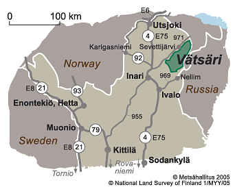
Vätsäri Wilderness Area is located behind Lake Inarijärvi, on the eastern side of the main road 4 (E75) from Ivalo to Kaamanen.
Directions
By Car
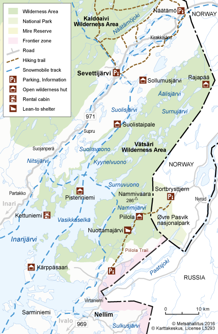
- Vätsäri Wilderness Area is located in the municipality of Inari, on the eastern side of Lake Inarijärvi. Road 971 from Kaamanen via Näätämö to Norway (120 km) runs along the northern shore of Lake Inarijärvi. The villages of Partakko, Sevettijärvi and Näätämö are located along the road. Road 969 from Ivalo to the village of Nellim goes to the southern side of the area. From Nellim, the road continues towards Kessi, and after the bridge over the River Paatsjoki it turns into a forest road, which ends a bit before Lake Kessijärvi.
- Driving directions to Siida.

By Public Transportation
-
There is a daily train service (vr.fi) to Rovaniemi, from where there is a coach connection to Ivalo. On weekdays, there is a coach service from Ivalo to Näätämö. Coach timetables (matkahuolto.fi). There is no bussconnection to Nellim.
-
There are daily flights (finavia.fi) from Helsinki to Ivalo.
Starting Points for Excursions
-
The villages of Nellim, Sevettijärvi and Näätämö are good starting places.
-
For boaters, the villages of Partakko and Nellim are recommended, because there are boat launch places in both. There are boat launch places also on the shores of Lake Inarijärvi. Boat harbours are in Inari, Veskoniemi and Nellim.
Maps
Elecronic maps


- Excursionmap.fi of Metsähallitus
Other Maps
-
Inarijärvi Vätsäri Tsarmitunturi, 1:25 000 ja 1:100 000 waterproof watermap. Calazo 2021.
-
Vätsäri Kessi Øvre Pasvik waterproof topographic map, 1:50 000, Karttakeskus 2020.
-
Sevettijärvi Nuorgam Outdoor Map, 1:100 000, Karttakeskus 2014.
-
Inarin osoite- ja virkistyskartta: Address and recreation map of Inari, 1:150 000, Lapland District Survey Office 2013.
-
Outdoor GT Northern Finland, 2016, 1:400 000.
- Maastokartat: Terrain maps nos W512, W514 and W523, 1:50 000, National Land Survey of Finland 2008 - 2009.
-
Inarijärven veneilykartta: Lake Inarijärvi boating map, 1:50 000, Finnish Maritime Administration 2012.

