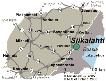
Siikalahti Directions and Maps
Siikalahti is located on the eastside of main road 6.

Directions
By Car
Siikalahti is located about 3 km from the centre of Parikkala. Turn off of main road 6 (Lappeenranta - Joensuu) at the Kaukola turn-off. Siikalahti parking area is located by the road. Siikalahti Nature Information Hut is 200 metres from Siikalahti parking area. 300 metres towards Kaukola from Siikalahti parking area there is an accessible parking area.
By Public Transportation
It is possible to get to Parikkala by both coach (matkahuolto.fi) and train (vr.fi). The coach and railway stations are about 4 km from Siikalahti. Parikkala is located 60 km from Savonlinna.
Starting Points for Excursions
- Siikalahti parking area is the starting point for the 1-km-long nature trail, which leads to the area's bird watching tower.
- There is an accessible lookout platform next to Kaukola parking area.
- The parking areas and nature trail at Siikalahti are not maintained during winter.

Maps


- Siikalahti brochure map (Pdf-file 1.8 Mb, julkaisut.metsa.fi)
- Excursionmap.fi of Metsähallitus
- National Land Survey of Finland map service (kansalaisen.karttapaikka.fi)
Other Maps
- Retkeily GT Etelä-Suomi: GT Outdoor Map Finland South, 1:250 000. Karttakeskus 2019. The maps are sold by Karttakeskus and well-stocked bookstores.
- Terrain Map M541, 1:50 000. The map is sold by the National Land Survey of Finland and Karttakeskus.
- Parikkalan retkeilykartta: Parikkala Hiking Route Map, Location Map 1:75 000. The map is sold at the Parikkala municipal office.
- Peruskarttalehdet: Basic terrain map nos 4123 04 and 06, 1:20 000. The maps are sold by the National Land Survey of Finland, Karttakeskus and well-stocked bookstores.


