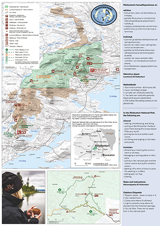
Riisitunturi National Park Trails

Recommended at Riisitunturi
Riisitunturi National Park is a breathtaking hiking destination all year round.
Read more about Riisitunturi hiking trails:
Trail to Riisitunturi Open Wilderness Hut, 1,5 km each way

Available when there is no snow on the ground. No winter maintenance.
A trampled path is also often visible in the winter
Travel time 30 minutes – 1 hour
Category:  easy –
  intermediate
Starting point: Riisitunturi starting point
Description of the Trail to Riisitunturi Open Wilderness Hut
Riisin rääpäsy, 4,3 km, Circle Trail

Available when there is no snow on the ground. No winter maintenance.
Travel time 2–3 hours
Category:  easy –
  intermediate
Starting point: Riisitunturi starting point
Description of the Riisin rääpäsy Trail
Riisin rietas, 10,7 km, Circle Trail

Available when there is no snow on the ground. No winter maintenance.
Travel time 4–5 hours
Category:  intermediate –
  demanding
Starting point: Riisitunturi starting point
Description of the Riisin rietas Trail
Other Trails
Riisitunturin reitti Trail, 26-29 km each way

Available when there is no snow on the ground. No winter maintenance.
Travel time 1–2 days
Category:  intermediate –
  demanding
Starting point: Riisitunturi starting point ja Kirintövaara resort
Description of the Riisitunturin reitti Trail
Kirinkuoppa Trail, 7 km, Circle Trail

Available when there is no snow on the ground. No winter maintenance.
Travel time 3–4 hours
Category:  intermediate
Starting point: Kirintövaara resort
Description of the Kirinkuoppa Trail
Kirinmatala Trail, 10,9 km, Circle Trail

Available when there is no snow on the ground. No winter maintenance.
Travel time 3–4 hours
Category:  intermediate
Starting point: Kirintövaara resort
Description of the Kirinmatala Trail
Winter Trails
Winter Trail to Riisitunturi Open Wilderness Hut, 1,5 km each way

Available when there is snow on the ground.
A trampled path is also often visible in the winter.
Travel time 1-1.5 hour
Category:  easy –
  intermediate
Starting point: Riisitunturi starting point
Description of the Winter Trail to Riisitunturi Open Wilderness Hut
Winter Trail Riisin rääpäsy, 4,3 km, Circle Trail

Available when there is snow on the ground.
Travel time 3-4 hours.
Category:  easy –
  intermediate
Starting point: Riisitunturi starting point
Description of the Riisin rääpäsy Winter Trail
Riisitunturi Multipurpose Track, 20 km / Partly Circle Trail

In winter, available by fatbike, skis or on snowshoes. Travel time 3‒8 hours depending on the mode of transport.
The trail is levelled 1–2 times a week, according to weather conditions.
Category:  intermediate –
  demanding
Starting point: Riisitunturi starting point
Description of the Riisitunturi Multipurpose Track
Skiing Trail Kirintövaara - Karitunturi, 7 km
Available February–April.
Travel time 1–3 hours
Category:  intermediate –
  demanding
Starting point: the Posio–Kirintövaara jogging track at the Kirintöjärvi roadside
Description of the Kirintövaara–Karitunturi Skiing Trail
Other Maps


