Porkkala Directions and Maps
Directions
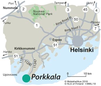
The recreational area and nature reserve of Porkkala is located in the south point of the municipality of Kirkkonummi.

By Car
From the Western highway (main road no 51) near the centre of Kirkkonummi, drive to Porkkalantie road (road no 11247) and continue that road for 19 km.
Option 1: turn right to Dragetintie road. Turn further right to Tullandintie road. There are several parking areas along Tullandintie road.
Option 2: turn left to Källvikintie road and you will reach the parking area of Lähteelä.
For more detailed parking area addresses, please see below under Starting Points for Excursions.
By Public Transportation
Coach service no 902 and 902K drives via Kirkkonummi train station to the bus stop at the end of Porkkalantie road, (bus stop Porkkala, ID Ki0901).
The route search of Helsinki Region Transport (HSL) (hsl.reittiopas.fi). The bus 902 and 902K do not operate on weekends.
By Boat
An easy waterway from Helsinki to Hanko runs through the area.
Starting Points for Excursions
The parking areas are the starting points for excursions.
There is a concrete boat ramp at Porkala Marin guest harbour.

Maps
Electronic Maps
Other Maps
-
Helsinki Porkkala Jussarö waterproof boating chart, 1:50 000, Karttakeskus 2022.
-
Helsingin saaristo (Helsinki archipelago), waterproof map, 1:50 000, Calazo 2021.
-
Retkeily GT Etelä-Suomi: GT Outdoor Map Finland South, 1:250 000. Karttakeskus 2019.
-
Maastokartat: Terrain maps K424 and K422, 1:50 000.
-
Vesiretkeilykartta: Water resistant water touring map, Porkkala-Helsinki-Pellinki, 1: 50 000, Karttakeskus 2014.
-
Veneilykartta: Water resistant boating map, Inkoo-Porkkala-Jussarö, 1: 60 000, Karttakeskus 2017.

