Pöyrisjärvi Menu
Pöyrisjärvi Wilderness Area Directions and Maps

Directions
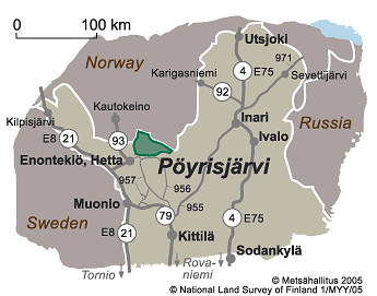
Pöyrisjärvi Wilderness Area is located on the north-side of road 956, which runs from the village of Hetta through Nunnanen to Kittilä, and on the east-side of road 93, which runs from Hetta to northern Norway. The northern boundary of the wilderness area runs along the Finland-Norway border.
By Car
- To get to the village of Näkkälä from Hetta, the municipal centre of Enontekiö, take road 93 north for about 25 km, then turn east onto the road to Näkkälä. Näkkälä is 14 km from this intersection.
- The village of Vuontisjärvi is located about 18 km from Hetta. It is on road 956, which comes from Hetta.
- To get to Kalmakaltio from Hetta take road 956 and drive for about 44 km to the village of Nunnanen. Then, turn left onto the road leading to Kalmakaltio. When coming to Nunnanen from the direction of Kittilä, take the road north to Köngäs and from there take road 956 to Tepasto and on through the village of Pulju to Nunnanen.
- The Hetta-Näkkälä Trail is easiest to get onto at Hetta at Fell Lapland Nature Centre.
By Public Transportation
- Coaches (matkahuolto.fi) travel from Rovaniemi to Enontekiö.
- Kittilä airport (finavia.fi) functions throughout the year on a daily basis. A connecting coach or airport taxi (enontekiolapland.com) service transport visitors on from Kittilä.
-
The railway station which is easiest to reach from the wilderness area is the one in Rovaniemi. Overnight trains, which can transport cars, travel daily from southern Finland to Rovaniemi. Train timetables (vr.fi). Timetables (matkahuolto.fi) for connecting coaches from Rovaniemi.
Starting Points for Excursions
- Good starting points for trips into Pöyrisjärvi Wilderness Area are the villages of Näkkälä and Vuontisjärvi and Kalmakaltio on the north-side of the village of Nunnanen. Another starting point for excursions is the village of Hetta. From there you can take the Hetta-Näkkälä Trail towards the wilderness area.
- Starting Points for Trails.
Maps


Other Maps
- Pöyrisjärvi wilderness area, waterproof map, 1:50 000, Calazo 2022.
- Pöyrisjärvi Kalmakaltio Hetta, Waterproof Topographic Map, 1:50 000, Karttakeskus 2021.
- Maastokartat, Topographic maps V423 Enontekiö, V424 Näkkälä, W413 Pöyrisjärvi and V442 Peltotunturi, 1:50 000.
- Outdoor GT Northern Finland, 2016, 1:400 000.


