Services in Neitvuori-Luonteri Area
Customer Service and Guidance
- The Neitvuori parking area and trail intersections have map signs.
- For more information on Neitvuori-Luonteri, visit Saimaa Nature Centre Riihisaari.
Services Offered by Enterprises and Organisations in the Neitvuori-Luonteri Area
These enterprises and organisations offering services in the area have a cooperation agreement with Metsähallitus and they follow the principles of sustainable nature tourism when operating in the area.
Meals, Where to Buy and Prepare
Anttola has shops and cafés, and is 22 km from Neitvuori by road. The nearest excursion harbour to Anttola is at Kaijatsaari.
Campfire Sites and Cooking Shelters
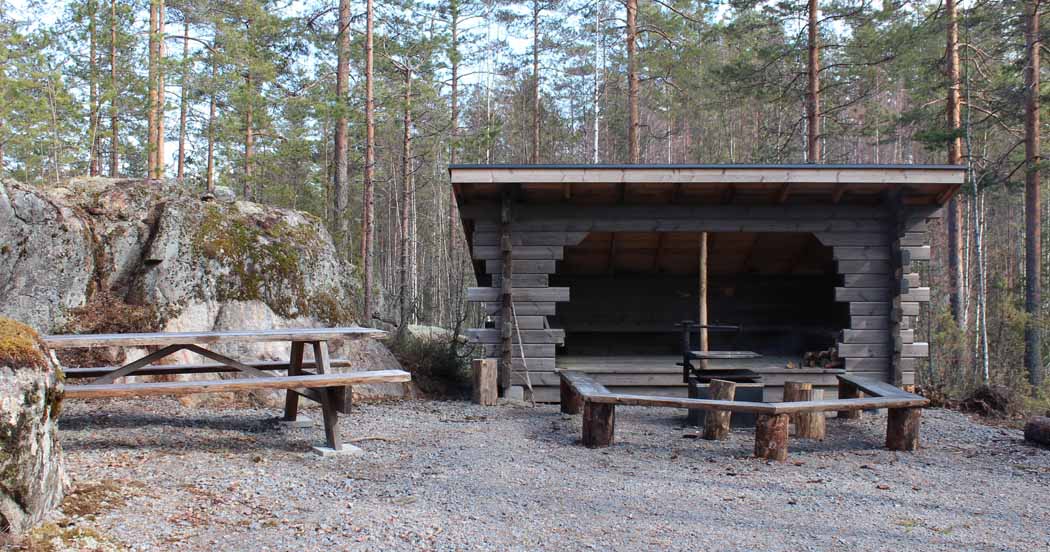
In Neitvuori
- The campfire site is located 1 km north of the parking area on the Hiijje silimukka hiking trail (PDF file, 1.4 Mb, julkaisut.metsa.fi).
In Luonteri
- Campfire sites are located at all excursion harbours. In addition to a campfire site, several excursion harbours also have a cooking shelter.
- There are also campfire sites in the northern part of Leskenluoto, in the cove at the southern tip of Pieni Huuhtisalmi, and at Uimasalo on the eastern shore of Sarkalampi, on Sarkavuori and on the eastern shore of Uimasalo.
Making campfires during forest fire warnings and grass fire hazards is also prohibited at campfire sites. Check for any warnings that are currently in force (ilmatieteenlaitos.fi).
The prohibition does not apply to cooking shelters or covered campfire sites with chimneys.
In high winds, hikers should avoid making a campfire due to the risk of forest fire. Making a campfire at a designated campfire site is described in more detail in the Outdoor Guide campfire instructions.

Drinking Water
There are no water points out in the field.
Read about drinking water tips for hikers in the Outdoor Guide.
Waste Management
There are no waste containers in the area, which means that waste management is the responsibility of the visitors. This means that hikers are responsible for their own waste and must bring it out of the area for appropriate sorting. Small quantities of paper and cardboard can be used as kindling and biodegradable waste is to be disposed of in a dry toilet. Hikers must carry all other waste out of nature in their own packs. Read more about litter-free hiking.
Dry Toilets
The farthest campfire site with a lean-to shelter in Neitvuori has a dry toilet and all excursion harbours have a dry toilet.
Overnight stays
Camping and lean-to Shelters
There are several excursion harbours in the Luonteri area and in its vicinity. It is also possible to camp in a tent at these harbours. Heposaari and Korvensaari are not suitable for camping in a tent due to the ruggedness of the terrain. There is also a lean-to shelter on Makutsaari island and on the Neitvuori trail. The service level of excursion harbours varies (further information).
- Raintasaari, western shore
- Vartiosaari, northwest shore
- Makutsaari, western cove
- Korvensaari, cove on the southeast shore
- Karihiekka, peninsula on the western shore of Uimasalo
- Kaijatsaari, western shore
Rental hut
Hiidenmaa farm, shepherding site. The hut is used by shepherds during whole rental period.
Excursion Harbours
Luonteri has several excursion harbours for boaters.
Camping is permitted at excursion harbours in accordance with Everyman's Rights (ymparisto.fi) for 1-3 days.
Where to Wash
The City of Mikkeli has a sauna available to hikers in Korvensaari. The sauna is maintained by the Saimaa Recreation Area Association (saimaanvirkistysalueyhdistys.fi, in Finnish).
Anttola harbour has a sauna (fee charged), washing machine and shower.
Lodging in the Surrounding Area
Information on nearby accommodation services can be found on the Mikkeli region website (visitmikkeli.fi).
Equipment Rental
Canoes are rented out by Outdoors Saimaa Guide Tiina (guidetiina.fi).
Special Services for Boaters
The shipping lanes in the area (2.4 m) are
Väätämönsalmi-Savivesi, 22 km
Anttola-Siikavesi-Enovesi, 24 km
Luonteri-Lietvesi, 12 km.
At Hiidenlahti Bay, there is a pier on the southern shore of Neitvuori at the bottom of the bay, which is only intended for the daytime mooring of boats. EUREF-FIN (~ WGS84) lat: 61° 39.99' lon: 27° 44.81' ETRS-TM35FIN: N: 6837255 E: 539543.
Read more about the excursion harbours and other boater services. For more information on excursion harbours, also refer to Käyntisatamat 2018 (satamaopas.fi, in Finnish and Swedish only).
There is a boat landing at Maaralansalmi, Anttola, Väätämönsalmi and Kuparovirta.
Other Services in the Surrounding Area
The nearest banks, service stations and other services are located in Anttola (anttola.fi), which is 22 km from Neitvuori. The nearest excursion harbour to Anttola is at Kaijatsaari.

